 |
Adventures in Camping, Backpacking, Trail Running, and Canyoneering Wahsatch Steeplechase |
> Home
|
Hiking Time | Trail Description | What to Bring
This report is a little different than my normal hiking adventures, for on this occasion, I participated in the 2008 running of the Wahsatch Steeplechase (www.wahsatchsteeplechase.com), a challenging 17-mile trail run full of climbs, scrambling over rocks, exposure, overgrown brush, and knee-pounding descents that made for a fantastic day. However, my report is mainly for the more casual runner . . . for the person who just wants to finish. Personally, I accomplished some modest goals I set for myself in that I just wanted to enjoy the views along the way and have a good time without breaking any bones barreling down the mountain. (My wife also said that it looked like I spent more time taking pictures and examining the wildflowers than really running.). I think anyone with some preparation can finish the course in the six-hour time limit. (I stumbled across at 4:26.). Yet, everyone might be able to understand more about the course by reading my running experience. You can read a description of the race by visiting their Website. The race begins at Memory Grove near the Utah State Capital Building at N 40.46.696, W 111.53.098.
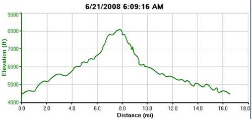
The total distance described here is about 16.5 miles (although the actual race details report that it is 17.5---I must have gotten lost and taken a misguided shortcut, my GPS was suffering from heat exhaustion, or the race is actually a little shorter), and it would consider it somewhat strenuous when you consider the climb, scrambling over and around rocks near the top, and the loose rock along the way. The starting elevation is about 4459 feet (measured using my Garmin Forerunner 205) and gains about 3,600 feet to around 8042'.
Well, if you're running and walking it, it might take you between 4-6 hours depending on how much training you have had. Personally, I don't run very fast, and my final time of 4.26, which was about the same time I did in a marathon two months before this race. If you planning on hiking the whole way, then I would add a few hours, let's say 7-10 hours, depending on how much you stop.
Date: June 21, 2008 For strarters, I would suggest you take a look at the maps (HERE) on the Wahsatch Steeplechase Website to give you more perspective on the trail. A number of months before the race, I ran across the Website and thought it sounded like a great race to try not far from home. I have a friend who has been involved in ultrarunning for some time, and his experiences peeked my interest. Having finished the Moab Marathon in April (a very small, but fun event from Dead Horse Point to just north of Moab, Utah), I wanted to try something offroad. I've never been interested in running with thousands of people in the city streets (with bands playing every mile or so), so the Steeplechase seemed a great way to test the waters.
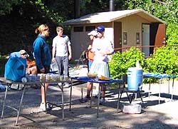
For some time, I had been training on the hills around the University of Utah to prepare, but I don't have the stamina to plow up hills, so my strategy was to walk at a good pace on most big hills, and run everything else. I knew my strategy wouldn't win any awards, but I wanted to make sure I returned home in one piece to my family. I arrived a little after 5:00 a.m. on race day with my normal gear, including two-water bottles full of my favorite sports drink and water. From experience, I've learned never to count on what aid stations might have (or not have), and I didn't want to be left unprepared. After a few short announcements (including a report on possible rattlesnakes and a weather forecast for scorching weather), the race started a few minutes after 6:00 a.m., as you can see here. (My wife was wondering why I was still taking pictures and not blazing out with the leaders . . .HA!)
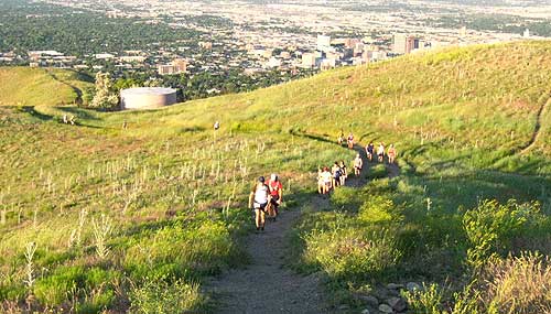
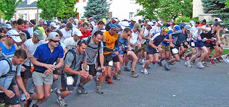 There were plenty of women in the race; the men just occupied the starting row. And look carefully: this is the last time I saw the leaders of the race. The first mile of the road followed the road up Memory Grove and then it followed the Shoreline Trail at N 40.47.416, W 111.52.707. However, although I could see the lead runners up on the hillside, a number of us still below became somewhat disoriented because some runners were heading one way, and others another way. I finally joined a group that left the dirt Hill Top Road at N 40.47.667, W 111.52.217, which continued to climb slowing until it reached the first aid station at about mile 4 at N 40.47.863, W 111.51.228. Check my watch: 7:07. Before this, I have found myself behind two runners who were going at my speed, and this helped me set a pace for the race.
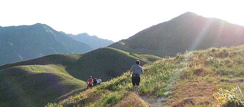
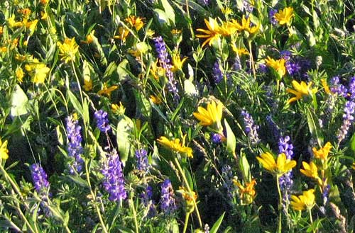
After a quick drink of water, I continued to climb until around mile 5, and then followed the undulating hills until about mile six. Of course, all of the elite runners were well heading down the mountain by this time, but since the field of runners had thinned out, I stopped to take a few pictures of the beautiful mountain flowers.
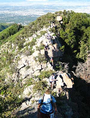
At just over 6 miles (N 40�48.428, W 111�49.209 - about 1:40 minutes into the run), the trail became much steeper. I had some light conversation with some of the runners throughout the race since no none was too concerned about passing the next person. What else is there to do when you are only moving 2 miles an hour? Finally, I reached what is referred to as the false summit. While you are not at the top, the leg-throbbing uphill climb is over. The map below details the next part of the route over the crags, down to Smugglers Gap, and then the barrel roll through the forest:
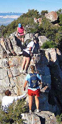
After a short distance up this false summit, I reached the crags at N 40.48.925, W 111.47.677. Having read a couple descriptions of this section of the course (along with a few pictures), I wasn't sure what to expect. I guess I was thinking it would be somewhat like my hikes to the top of Lone Peak (see report HERE), full of hands-on work with severe exposure on all three sides once you are at the very top (I mean hundreds of feet on the way done ---- like you could almost base jump from the top). Lone Peak and other similar hikes are definitely not for the faint-hearted. However, the crags turned out to be a fun, short-scrambling effort that leads you up to the summit. You really can't fall of the edge unless you faint or careless. On this occasion, it was nice to see people working together to negotiate the crags, and there were a couple of race volunteers who where there a one spot in the middle of the crags to help you with your footing in getting down one spot. No one was in a real hurry to get by, and people around you wanted everyone to succeed.
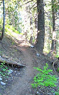
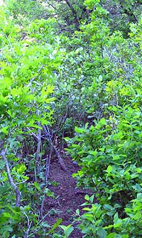
After passing the crags and reaching the summit a short distance away, the trail meandered down to Smugglers Gap and the second aid station at N40.48.973, W 111.47.548. The station was nicely stocked with drink, candy bars, and other items. I didn't waste much time here and took off down the forest trail at 8:46 a.m. Two men departed at the same time and pulled head of me, and for the next 45 minutes, I was alone heading down the trail. We were warned that the trail was filled with overgrown brush, snarling roots, and loose dirt.
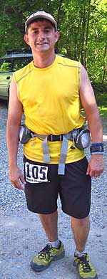
Besides slowing down my pace to avoid any face-falls, the trail was uneventful. The pounding of the downhill run was a little hard on the joints, but I was glad to emerge at the bottom at at 9:13 a.m. at N 40.49.566, W 111.47.239. I was just glad I wasn't surprised from a moose in the thicket. That would have been ugly. Once at the bottom, it was a short, 4-minute jog to the third aid station at N 40.49.473, W 111.47.621. I had some Gatorade and a few bite-size candy bars, had my picture taken, and then pulled out for the last seven miles of the run.
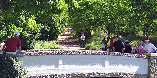
From this point on, the run follows the Mill Creek Road and then leaves the the road onto a trail after the waste treatment plant until in returns to Memory Grove. Unfortunately, I somehow missed the fourth aid station (I might have stayed on the paved road too long), but someone redirected me so I got on the right trail. Fortunately, I usually carry more water/sports drink that I need, and in this case, I was on fumes when I pulled into the finish line (seen in the picture below). What was nice is that the entrants were really spread out over the last seven miles, and I was running alone most of the time.
Summary: This was a great race with a little of everything. Personally, I really enjoy a friendly, more non-competitive experience (at least for those running at the back of the pack). Everything was very well organized, and I would consider doing it again.
I'd bring everything you would need for a trail race, including extra water, in case aid stations don't have what you need. On this day, the day heated up into the mid-80s by the time I finished, so you don't want to be caught without the necessities.
|
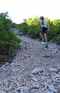 Most people around me were walking most of the hills, but the next part up the mountain was a slow trudge, and it took me a hour to do the next two miles (in part because of the steepness of the trail and the negotiation of the crags). I briefly stopped a couple of times to catch my breadth, snap a few photos, and resume the hike. The trail is filled with loose rock of all sizes, and having a good pair of trail shoes did help.
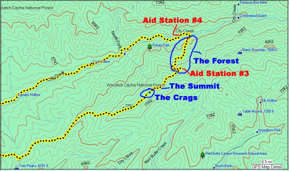
| Other Sites |