 |
Adventures in Camping, Backpacking, Trail Running, and Canyoneering Lone Peak
Via Draper Ridge and Bear Canyon Trails |
> Home
|
Hiking Time | Trail Description | What to Bring
[ NOTE: The initial approach is the same for my other trail report on climbing Lone Peak HERE.] Orson Smith Trailhead (N 40.31.297, W 111.50.32) located near 12601 South 2000 East. You can routefind east up to the actual trailhead at N 40.31.250 W 111.49.767. The trailhead is marked as "Cherry Canyon Logging Trail", but it's also referred to Bear Canyon Trail. USGS Draper (UT). Click HERE to view the approximate starting coordinates and map.
The trail description and routing for this hike is anywhere between 11-13 miles, depending on detours and route finding. The first couple of miles are the same as the last few with the middle part of the hike forming a long loop, allowing you to see most of the mountain on one trip.
About 12 hours round trip.
Date: July and August 2007 [NOTE: I made this hike twice in a month's time, and my report is based on a composite of these experiences.]
The trail switches back as it climbs the first couple of miles, with several very nice viewpoints along the way. The plant life as well as the topography changes, from scrub oak at the bottom to twisty juniper trees farther up. The trail levels off somewhat before you reach a trail junction at N 40.30.824, W 111.47.908. At this point, we (my friend, Duncan, and I) headed south on my first hike in July, and within a hundred feet or so, the trail veers southwest and slowly disappears. We continued to lose elevation and finally bushwhacked our way back up to the Draper Ridge Trail at N 40.30.589, W 111.48.043. However, when I tried this route in August with my brother- and sister-in-law (Brad and Diane), we stayed at the same elevation from the previous trail junction, crossed about .2 miles until we connected with the Draper Ridge Trail at N 40.30.664, w 111.47.827.
At this point, you encounter a tiring climb for about .3 of a mile with no switchbacks, which levels off and then slowly climbs until reach the junction of the Draper Ridge and Jacob's Ladder trails at N 40.30.756, W 111.47.330. Continuing on several hundred feet will bring you to a rise with your first full view of Lone Peak, your destination, in the distance. This is a good place to sit and relax for a few minutes.
For the next .89 miles (as the crow flies) or so, you first walk down and then through a pretty level meadow, which could serve as a camping ground on a two-day trip and then follow rock carins until you reach a junction. Taking the left fork will take you to the Outlaw Cabin at N 40.31.200, W 111.46.883 (see my report of Lone Peak Viewpoint for more information on this area). Instead, continue your journey straight on the main path, climbing several boulder fields, passing a stream along the way until you reach the basin below Lone Peak. The high granite walls make the whole area very impressive.
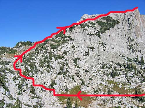
From this point on you basically follow a number of carins to the top. The easiest approach might be to walk northeast through the bottom cirque, climb up to the saddle, and then follow carins and a scant trail to the top. The picture below shows the basic route, and this image was from the west on our return trip down the Bear Canyon drainage.
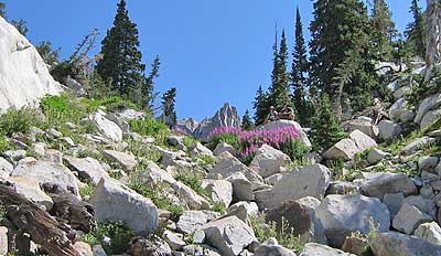
The approach towards the top is fairly simple; at times there is a trail, and at other points, you are looking for small cairns along the way.
The last three hundred feet or so require some hands on maneuvers. I had read numerous reports on the final approach, and I was expecting something more dicey, but it's still not for the faint-hearted soul. At approximately N 40.31.656, W 111.45.377, you'll find a good place to set your packs and take a breather and a drink before you scramble your way to the top.
See Video - Windows Media Format (944 KB, 1:13 long). This short movie will give you an idea of what to expect on your hike.
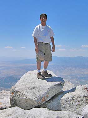
There are a couple places with some exposure, so watch your step. To be honest, I was a little scared at times on both trips (July and August) because I don't like heights with the possibility of tumbling down the mountain, and on the July excursion, I stopped just shy (10' or so) of the top rock. I felt a little lightheaded at the sheer drop of 600+ feet on three sides of the top. However, on my return trip weeks later in August, I got the courage to climb up and claim the summit.
On the return trip in July, Duncan and I simply returned back the same way we came (we had already hade a Lone Peak hike twice before) , but in August, I decided to show my companions as much of the mountain as possible by creating a loop in the hike. We headed back down to the saddle we came up before reaching the summit, then crossed over to N 40.31.512, W 111.45.932 at the top of the Bear Canyon drainage, headed west down the drainage for .91 miles to the Outlaw Cabin and then winded back down mountain, past the spring, and to the trailhead. More details on this final part of the route can be found in my earlier report of Lone Peak Viewpoint. Personally, the hike to Lone Peak is one of my favorites in the area. Each time I have climbed the mountain, I have met only a few hikers on the trail, so you can really feel the scerenity being above the hundreds of thousands of people below in the surrounding valleys. It's a quiet, scenic hike, but it will wear you out, so I suggest doing some conditioning beforehand. This probably shouldn't be your first hike of the season.
Commonsense, a lot of water, and food for the day. Having a GPS can be extremely helpful in pinpointing the route. Consider bringing a water filter if you are unsure about the water conditions at the spring. Water can often be found at different points along the trail, but this can be an unreliable water source.
|
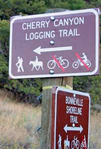 Once you reach the actual Cherry Canyon Logging Trailhead, your adventure begins. I climbed Lone Peak twice in one month, and my report is a composition of these two hikes.
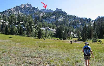
| Other Sites |