 |
Adventures in Camping, Backpacking, Trail Running, and Canyoneering Sentinel Rock |
> Home
|
Distance and Difficulty | Hiking Time | What to Bring
You can start your hike near N 40.28.650, W 111.38.916 on the west side of the road right before Tibble Fork Reservoir, which is located up American Fork Canyon in Utah county. Newton Canyon, USGS Timpanogos Cave (UT) Topo Map. Click HERE to view the approximate starting coordinates and map.
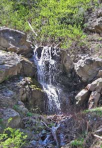
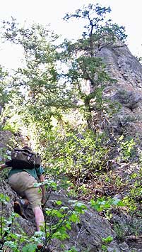
The hike pretty much begins by following along the creek bed, which is often dry during the summer months. We made the hike mid May, and although the lower part was relatively dry, there was still flowing water higher up, as you can see from the picture of the falls. The flowing water can provide a respite for dogs (if you think they can make it) or for you if you have a handy filter with you. The waterfall is found at N 40.28.597, W 111.39.554. After the falls, we veered in a slightly southwest directly headed directly for Sentinel Rock (as my companions named it) at N 40.28.483, W 111.39.661. As you approach the area, you may see rock walls and ledges through the trees in the distance. Because you will be in the trees up to this point, you loose perspective on how much elevation you have gained over the relatively short hike.
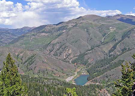
See Video - Windows Media Format (871 KB): I named one of the peaks in the video as Mill Creek Peak, but actually, it is called Mill Canyon. Also, I originally called Sentinel Rock as Devil's Overlook, but the other name stuck. Once you reach the top, you will be greatly rewarded by the beautiful views of the canyon below. Tibble Fork Reservoir will be directly east of you will other prominent peaks in the distance. Soak up the serenity because you won't run into anyone on this hike. Returning back to the the start requires you to basically follow the stream back to the road. Since there is no trail, you probably won't be returning the same way. This isn't a hike I would repeat over and over again, but it was worth the thrill . . . once . . . of going where few people roam on an adventure of route finding using a GPS and some basic orienteering skills.
This hike is only about .75 of mile, but with no trail and plenty of brush to contend with as you gain close to 2,000 feet in elevation, I consider this a difficult hike. The reward of the view only comes at the end, so don't plan on giving up halfway.
About 4-5 hours, depending on any stops along the way.
Plenty of water, food, long pants if you don't like to scrap up your legs, 50 feet of rope (optional), and a good GPS.
|
| Other Sites |