 |
Adventures in Camping, Backpacking, Trail Running, and Canyoneering Red Mountain 50K |
> Home
|
Cut-Off Times | Race Description
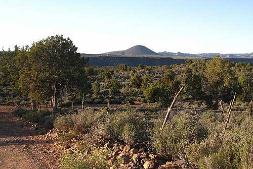
The Red Mountain 50k race started back in 2008 by race directors, Adriane, Phil, and Jeremy, and it was held again in 2010 after a one-year break. The official Web site for the race (Red Mountain 50k) describes the event in detail and directions on how to get to the area. (The starting point is shown below.)
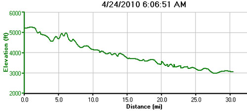
You really can't describe an ultramarathon as being easy, for there really isn't an "easy" one. They are all long. In fact, from a quick glance of the elevation chart of the race, it appears deceptively all downhill. Notwithstanding, the blend of trail and pavement and the gentle downhill course with some rolling hills can provide new racers a nice introduction to ultrarunning at the 50K distance. This profile below only displays 30.58 miles of the course because I inadvertently turned off my GPS watch for a few minutes near the end of the race.
The official cut off time for the marathon was 7 hours, but runners were allowed to continue on their own after that time. I'm usually near the back of the pack, in part because I'm not very fast, and I also like to chronicle the event in pictures and video. However, events like these allow you to enjoy the scenery without the noise of bands and traffic noise along the course.
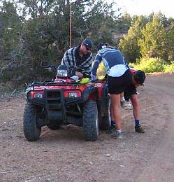
When I heard about the innagural running of the Red Mountain 50K in 2008, I thought it would great event to try during the spring between the other races that I wanted to try. Unfortunately, I wasn't able to run it that year, but once I saw it was being held this year, I decided to give it a shot as a precursor to other summer runs. My wife, youngest daughter, and I arrived the night before the race to pick up the race packet at St. George Running Center in the evening, and I was warmly greeted by the race organizers. I planned on switching to road shoes after the first 12 miles when the course hit the pavement, so I left my road shoes in a bag to be transported to the aid station at that point. Also, the goodie bag that runners received had some good stuff in it. Afterwards, we went out to eat dinner to celebrate a birthday, and we returned back to the hotel to get some sleep. Morning came quickly, and after having some breakfast in the room, my wife took me to the starting point in the town of Central instead of riding the provided transportation from Unity Park in Ivins (having checked on this option with directors the night before). In fact, it was nice to have them cheering me on at the start of the race. We arrived about 15 minutes before the race began, and some drink and food items were on hand for runners. The excitement began to build in the dark, culminating with the playing of the Star Spangled Banner. Then, after a few brief moments, we were off running in the dark. A number of runners were wearing headlamps; I knew the sun would be up shortly, so I just tried to watch my step and follow the light from the other headlamps and support ATVs (which are on hand to provide aid, duck tape for shoes, etc.) that followed runners for the first couple of miles of the race.
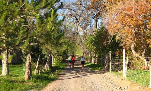
My race plan was simple: take lots of picture and video, not get injured, and complete the race before nightfall (well, before the cutoff). The first seven miles or so were somewhat hilly on a dirt road, and I found myself running and power walking up some of the steeper sections. During most of this part, there were always a few people ahead and behind me, but with the small number of participants in the race (under 60), runners quickly spread out. Without much running traffic along this section, I was able to set up my tripod and video camera and get some good shots of the area. My wife wonders if I spend more time using my camera than using my shoes, but with the uncertainty of ever coming back, I'd rather capture some visual memories. Unmanned aid stations with water, heed, and gummy bears, and some medical supplies were set up at miles 3 and 6. Although the morning was cool at the starting line, I got warmed up quickly and took off my long-sleeved shirt near the start of the race.
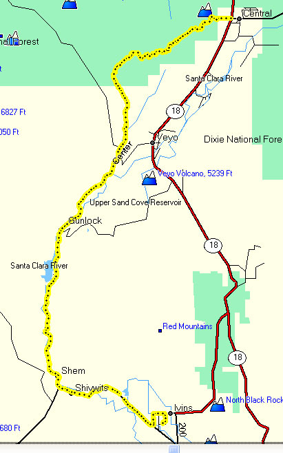
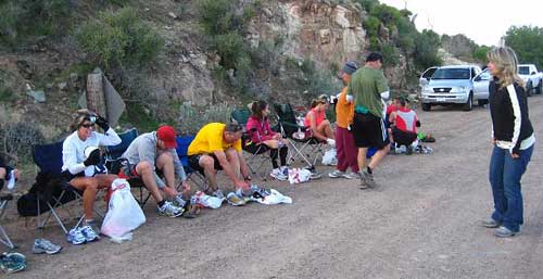
Right after mile 8, the terrain levels out as you cross a couple of very small intermittent streams until you reach the aid station at mile 9. It was nice to seem some friendly aid station workers at this point. The station was stocked, and after a brief moment there, I pushed forward. The trail was pretty flat for the next mile or so, and you had great views of a cinder cone volcano in the distance to the south, one of several in the area that last erupted around 25,000 years ago. Around mile 11, the road continues downhill and passes by some green farmland and along a stream . . . a nice change of scenery after miles of other desert vegetation. This continues until you reached the end of the dirt road and the beginning of the pavement at mile 12. Chairs were available for you to sit for a minute and switch your shoes. I grabbed a new food items at the aid table, left my other shirt behind, and away I went at my slow, comfortable pace.
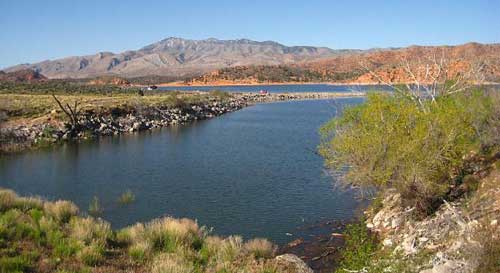
By this time, the runners were very spread out along the road, and at times you might find yourself somewhat alone. From miles 13-15, you run along Highway 91, a lesser-traveled road leading into the small town of Gunlock, named after William Haynes Hamblin who reportedly was known for his sharpshooting skills. Once again, the aid station at mile 15 was well stocked with a friendly crew, and I was still feeling fine as I rolled into Gunlock. After passing through Gunlock, the road continues south, with sandstone bluffs lining the east side of the road. The lone woman at the mile 18 aid station whipped me up a peanut butter sandwich at my request, and it gave me a boost as I enjoyed the views of Gunlock State Park and the reservoir off the west of the highway. The nice thing about this entire road was the absence of any significant traffic along the way.
My family greeted and cheered me on along the road at about mile 23, and they stopped a couple of other times to encourage me. By that time, it was hard to really tell how many people were ahead of me or behind me, but some of the same people I saw earlier in the race were going about the same pace. At mile 26, the road gently climbs a short distance before heading south east. At that point, I realized that, although I didn't really have a goal coming into the race, I'd at least try to reach the finish line somewhere under 7 hours, I could possibly . . . with some luck . . . make it around six hours. Between miles 20-25, I felt somewhat drained, but my energy level seemed to pick up a little as I approached the final aid station around mile 30. My family pulled up near me to give their final cheer, and once again seeing that I could actually come in under 6:00 for me would be an accomplishment. I pushed hard during the last mile and finished in 5:50, for an 11:18-minute average, to the cheers of my family and volunteers. After collecting my gear, we spent some time exploring the area around the Snow Canyon area and hiked the Cinder Cone trail of the volcano just north of the state park.
The Red Mountain 50K is a race that is just right for beginners and more seasoned ultrarunners who are looking for a well-supported race in a scenic area and don't want to feel too beat up at the end. I've been in longer and more rugged races, but this one felt just right. In fact, although the St. George Marathon is very popular, boasting thousands of runners annually, I find that a small race like this one, where you are at times alone and not dodging other runners, so much more pleasurable. And having top-notch race volunteers treating you well even when you run closer to the back of the pack in a small event makes the experience a real pleasure.
|
| Other Sites |