 |
Adventures in Camping, Backpacking, Trail Running, and Canyoneering Millcreek 50K Trail Race |
> Home
|
Cut-Off Times | Race Description
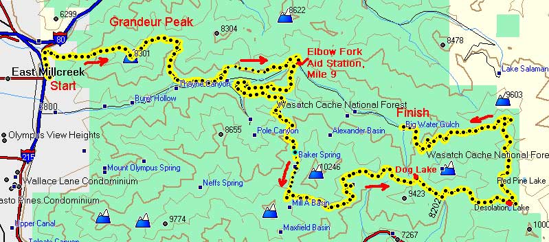
There is no official Web site for the race; however, links to previous reports can be found at the bottom of this page. The starting point for the race is Eastwood Elementary, 3305 Wasatch Boulevard, Salt Lake City, UT, as seen in the map below:
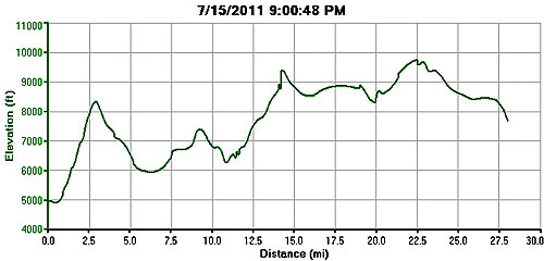
The elevation chart and basic map of the area are seen here. Unfortunately, I accidently turned off my GPS a couple of times during the race, so the actual measurements are not complete. I have also provide some approximate GPS coordinates for different points in the race, which were either waypoints I did myself as I previewed the course, or where calculated using topographical maps. Therefore, they should be viewed as estimates and tentative guideposts (i.e., use them at your own risk), but they were very helpful to me in helping me mentally stay in a race I had never done before.
A Forest Service map of the trails in the area can be downloaded HERE.
The race course covers approximately 31 miles with well over 10,000 feet in elevation gain over that distance. The starting point of the race alternates from an up-canyon course starting below Gradeur Peak and ending at the end of the canyon road at Big Water, and then the following year, running basically in the opposite direction. Because of the time of day and the race being held through the early hours of the morning, it can be an exhausting event. As with my other running reports, I give my synopsis of the run from the back-of-the-pack perspective.
There is no official cut off time, with most people finishing within 12 hours or so.
Mill Creek Canyon (also written Millcreek Canyon) is an important part of the history of the Salt Lake Valley area since the early Mormon pioneers arrived in the valley in the 1840s. Because the desert landscape provided few trees on the valley floor, places like Mill Creek because the source of lumber for the needs of the early settlers. Saw mills sprang up in this area for many years, in addition to mining activities.
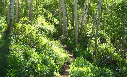
Today, Mill Creek is a popular area for bikers, hikers, and dog lovers who want to get out into nature in an area so close to city life. The Millcreek 50K has been held since 2003, and the current race director, Rich Baxter, has done an excellent job in organizing a no-fee race on a very unique and challenging course. I had been eyeing this event for the past three years, hoping to have a chance to try it when my schedule, and the stars, aligned just right to make that possible. The idea of starting a race and running/completing it throughout the night just appeals to a different crowd, and I felt I was ready to give it a try. In the weeks up until the race, I collected information about the course, and the Saturday before, I decided to give a section of the course a try from the Terraces Picnic Area (40.41.844, 111.42.957) to Baker Pass (40.39.860, 111.41.628) and then down the other side for about a mile or so. This section would cover approximately five miles one way, and on race day, would comprise roughly miles 11-16. Having some feel for the course and plotting some GPS coordinates for specific points along the way would help me have some sense of the terrain and boost my confidence level a little. I just didn't want to muddle in the dark with no sense of direction, even though the course was marked with flags and reflective tape. My pre-race jaunt into the mountains was somewhat uneventful. The first 1.1 miles of the Bowman Trail takes you along a stream under a canopy of trees as you enter Mount Olympus Wilderness Area. At 1.25 miles, you follow a short series of switchbacks until you emerge out of the coniferous forest at White Fir Pass at 1.7 miles. At this point, the trail changes from a very wide, and smooth, dirt trail to a more narrow and rocky path. Hmmm. What would it be like in the dark?
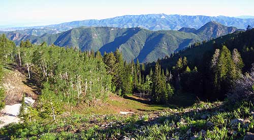
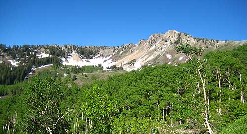
The trail then narrows a little as it heads south and passes Yellow Jacket Gulch as you enter a forest of aspen trees leading up to Baker Spring, the only reliable spring running out from a pipe on this part of the course. This is where I caught sight of a moose heading away from the spring into the trees---beautiful creatures from a distance. Baker Mine (or Hayes Mine) lies just a short distance south of the spring outside of view from the main trail, and it was the site of an old camp mining for gold and copper. The general area of the mine site is said to be located in the vicinity of 40.40.205, 111.41.275, but I haven't confirmed this myself. Please let me know if you have the precise coordinates. There were very few patches of snow covering the trail from Baker Spring to Baker Pass. I ran across a few fellow runners preparing for different events, and I enjoyed catching some great views of the surrounding mountains, including Gobblers Nob and Mt. Raymond, both rising over 10,000 feet. A great place to rest and even have a picnic would be at Baker Pass between these two peaks, offering great views into Millcreek and Big Cottonwood Canyons. Often times, I often reflect on how different geographic features get their names; as for Gobblers Knob, it has been suggested that it was named after the fact the miners kept a flock of turkeys in the area.
Well, perhaps that is enough on the local area and history. So much could be written on Mill Creek Canyon, but you're probably wanting to know about the actual race, and not a nostalgic recap of the area. Here we go . . .
After a long day at work and evening, I arrived a couple of minutes before the race started. It was a good crowd of 61 runners who were ready to give this run a try. After some brief comments by the race director, the race started along the pavement for a few minutes until we hit the climb up Grandeur Peak. It was around this time that I realized that although I had my camera, I had forgotten my battery at home (rats!). I wasn't planning on taking too many pictures in the evening, but I knew I would probably get a few nice shots of the canyon from the top in the morning.
The next few miles were uneventful until Elbow Fork. I ran alone most of the way, and there were a number of switchbacks that slowed my pace a little. I arrived at the aid station at Elbow Fork in 2:52 (just before midnight), grabbed a few items, and then took off. The first mile of this next session towards the Terraces Picnic Area climbs slowly, and I just didn't have a lot of energy to do anything more than walk. Once I reach the top of this segment, I ran most of the way down to the start of the Bowman Trail at 40.41.844, 111.42.957. At one point, I slightly twisted my ankle, but having done this before, I knew that I could shake off the discomfort, which generally only lasts a few minutes.
The next miles to Baker Spring felt like a death march, one foot in front of the other, but I was glad I had done this route in the daytime the week before. I began to ask myself whether I really wanted to do the whole race or just bail at Dog Lake. My body felt pretty good . . . very tired . . . but still moving. My goal was to reach Backer Pass by 3:00 a.m. Except for seeing a hearing a few runners, the surroundings were completely quiet. It was nice to have the full moon out, a real psychological boost in the dark. Not far behind me, I could a very merry group of runners breaking the silence of night sky, which is one way to pass the hours on the trail. Once at the pass, I decided to lie on the ground for a few minutes to enjoy the peaceful evening and to rejuvenate a little, something I needed. The miles between Baker Pass and Dog lake went slowly. The trail isn't as clear as are other parts of the course, but it was easy to follow. My determination to complete the entire course wavered from moment to moment. I just wanted to reach Dog Lake (40.40.075, 111.38.415) by 5:00 a.m. and then would make a decision from there. In the meantime, my mind began to wonder, and I on a number of occassions, thought I had heard and seen a large moose or black bear in the dark shadows. Spooky. As I was arriving at Dog Lake, another runner decided to call in a night and take the Big Water Trail three miles to the finish line. There was a lone aid worker waiting in the dark with some water, pretzels, and other small treats. Hard to believe that someone would be willing to spend the evening waiting for the back of the pack to make it through. Once again, I decided to take a short nap on the ground to rest. Another runner came through heading toward Desolation Lake (2.6 miles beyond) and the last 10 miles of the course. Hey, 10 more miles . . . I've been in similar situations before, and I knew my mind would come around, so I started to jog down passed Dog Lake until the trail converged with the Mill D North Fork Trail heading in a easterly direction. The next mile was slow as the trail climbs and then levels off as you approach Desolation Lake. By this time, the morning sky was shedding its darkness, and I sat down by the trail near Desolation Lake to enjoy the view and have a sandwich. A few runners came by after a few minutes, and I then got up to climb out of the basin to connect with the Great Western Trail. It was after 6:00 a.m. that the sun was coming up, illuminating the entire canyon, and the views to the east and to the west were just spectacular. These are the times when you don't mind at all being at the back of the pack of a race. I just wish I could have taken pictures at those moments. Also, had I had more time, I would have sat and relished the sights for a much longer time. The race course then winds back to the west ending at Big Water at the top of Mill Creek Canyon. At the end of the race, I was greeted by the race director who was making pancakes for the finishers. A great way to start the morning. Of 61 starters, 39 completed the event (63% completion), with others starting either at Elbow Fork (mile 9) or heading to the finish line at Dog Lake. I finished within 15 minutes of my projected time . . . well behind the winners, but still with the satisfaction of dragging my body to the end.
|
| Other Sites |