 |
Adventures in Camping, Backpacking, and Canyoneering Arches National Park: |
> Home
|
Distance and Difficulty | Hiking Time | What to Bring
South Park Avenue Trailhead, USGS The Windows Section, Arches. Click HERE to view the approximate starting coordinates and map.
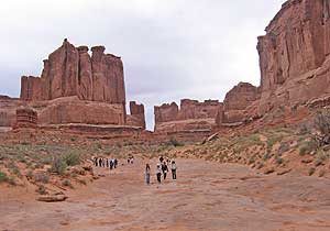
Most visitors to the park stop at the Park Avenue Viewpoint, snap a few pictures, and return to their cars without really exploring this amazing trail along dry wash bed between enormous towering walls of red sandstone. It becomes obvious how this area got its name. However, you will miss so much of the park and even its wildlife if you go no farther. From the Park Avenue Viewpoint heading north, you will follow some roughly-made steps for a short distance down into the wash and then the rest of the trail is mark by cairns along the way. The area is populated by a few strangely-twisted juniper trees that will interest all visitors.
After a while, the trail opens up to a wide dry wash, filled here and there with a number of shallow sandstone basins or ephemeral pools (potholes) carved out by erosion. One of the best kept secrets of the desert is what occasionally springs forth from water that collects in these potholes. One of these invertebrates is the small fairy and tadpole shrimp. For most of their lives, they lie dormant as eggs buried in the dirt at the bottom of these potholes.
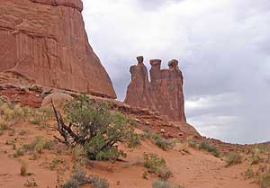
Once you reach what I named Gossip Rock Viewpoint---a big rock--(N 38.37.957, W 109.36.034), you will see the Three Gossips to your left (Northwest) at (N 38.38.150, W 109.36.193). Climb up and take a picture. From there, you will reach the end of the trail at N 38.38.190, W 109.36.001. The last feature you might see is The Organ, east of the road at N 38.38.180, W 109.35.874.
An easy (and downhile) one-mile hike, losing about 300 feet in elevation starting at the Park Avenue Trailhead.
About 45 minutes, with time for taking pictures and absorbing the views.
Nothing particular besides good hiking shoes.
|
| Other Sites |