 |
Adventures in Camping, Backpacking, Trail Running, and Canyoneering Grotto Trail |
> Home
|
Hiking Time | Trail Description | What to Bring
USGS Wimmer Ranch Creek, USGS Payson Lakes (UT). Click HERE to view the approximate starting coordinates and map. The trailhead starts on the left side of the road as you are ascending the Loop from the Payson side. You can park along the road. [From Northern Utah County]: To reach the Grotto Trail, get off I-15 at Payson Exit 254, turn left onto Payson Main Street (State Route 77). Continue south until Main Street meets 100 North. Turn left and travel east to 600 East, then turn right, and follow this road south to the entrance to Payson Canyon and the beginning of the Nebo Scenic Loop. The trailhead is about 7 miles up the road.
About .3 of a mile from the trailhead for an easy hike for the entire family.
About 45 minutes round trip, depending on how much time you spend at the grotto. Best seasons: Late spring to early fall.
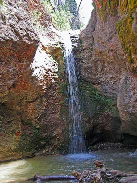
The first time I made the hike was back in 1987 as I was looking for a spot to hold an activity. Back then, the way to the grotto was not much more than a faint trail through the brush; I was very surprised to see the major improvements to the trail in 2006, almost 20 years later. Such changes provide better access for people of all ages. Today, the trail gradually gains about 200 feet of elevation from the trailhead to the grotto, cutting across the stream on log bridges in several places. The trail ends right at the mouth of the grotto (N 39.56.911, W 111.40.670), with the stream flowing in from above. A shallow pool of water forms at the bottom of the grotto, but the waterfall rages during the spring runoff. See Video - Windows Media Format (352 KB) Perhaps the best and safest time of year for children is from July to September, when the waterflow is lightest and the air temperature is warmest to balance the frigid water from the stream. It is a fun place for kids to play in the water and even stand underneath it. It would also be a romantic place to take someone on a date, but you probably won't be along on busy weekends and holidays.
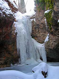
You can reach the point above the waterfall by hiking up a trail just left before entering the grotto. The trail ends there, but you can follow the creek up for a nice hike through the forest. More information on the area can be found on the Unita National Forest Website HERE. Hiking to the grotto during the winter is also a very fun adventure, especially when the waterfall freezes into an almost solid chandelier. The road is closed farther down the canyon, so you can expect at least an hour hike to reach the grotto, but it is well worth it.
A towel or other swimwear for the kids . . . or a candlelight dinner, engagement ring, and a catchy proposal for the one you love.
|
| Other Sites |