 |
Adventures in Camping, Backpacking, Trail Running, and Canyoneering Ultimate XC Moab 50K |
> Home
|
Running/Hiking Time | Race/Trail Description
This report highlights the inaugural running of the 50k, 20-mile, and 10-mile trail run held by (www.ultimatexc.com), known for their other challenging off-road ultra experiences in the US and Canada. This year, I participated in the 50K, and like many of my other reports on hiking and running, my experience is mainly for the more casual runner . . . for the person who just wants to finish. (I tend to enjoy spending a lot of time taking pictures and video, and even exploring a little, to call it a race for me).
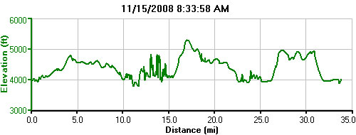
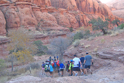
The 50K actually turned about the be about 2.5 miles longer than announced, but this can sometimes be expected. There were three climbs: one at the start, another about mile 15, and a final about mile 25.5. What also made the race challenging was the sand on almost all parts of the course and the sand hill about mile 28. You felt like you were running along the beach with no water in sight . . . unless you were hallucinating. Definitely challenging.
Well, are you planning on keeping up with the elite runners or just wanting to finish? The top runners finished in about 5.5 hours; my headlamp and I finished the race right at the 9-hour cut off time in the dark, running and hiking quickly at an average rate of 3.7 miles an hour. Runners had to finish the first 20 miles (actually about 23.5) under the six-hour time limit to be allowed to continue. These and other cut offs were in place due to very understandable safety concerns.
Date: November 15, 2008
For some time, I had wanted to do a trail run in the Moab area, having been there many times with my kids and students, and the remoteness of the area is just so appealing to explore. My first trip to Moab was about almost 20 years ago when my oldest daughter was one, but I never started running until my early 40s (I just couldn't see myself hitting the city streets; just not fun at all). However, I've enjoyed hiking for years, and the opportunity to combine hiking with running grabbed my attention, especially since I became friends with a ultrarunner/geocacher who had done and survived 100-mile races. I spent most of my time training along the Bonneville Shoreline Trail in Salt Lake City and up American Fork Canyon in Utah Valley, and I tapered my miles a few weeks before the event. I wanted to make sure I did enough miles on the trails without injury. I wasn't concerned about competing for an elusive top spot; rather, I just wanted to complete the run while taking pictures and exploring the backcountry during the race.
My wife was originally going to join me and run the 10-mile race, but she wasn't able to come, so I convinced my brother to go along and support me along the way. The evening before, I picked up my race packet at Milt's Stop & Eat (http://www.miltsstopandeat.com), the race headquarters for the evening. I had a few questions answered about the course, and we headed back to the hotel for the evening. I usually don't sleep well before a race, but I was out pretty quickly. After an early breakfast, we headed out to the meeting area (N 38.31.953, W 109.36.012) in time for the 8:15 a.m. runners' meeting to go over the course, and I left my one drop bag (in my case, a bucket) there. Basically, all runners for 10-mile, 20-mile, and 50K races would start the race at the same point and follow the same course for the first 10 miles or so. At that point, the 10-mile runners would follow a route across a creek and back to the finish line (which was basically at the same general spot as the starting line). The 20-mile and 50K runners would then follow the same route until they both returned back to the starting line in one giant loop. Then, the 50K runners would go out for 10 more miles on a completely different section of the course.
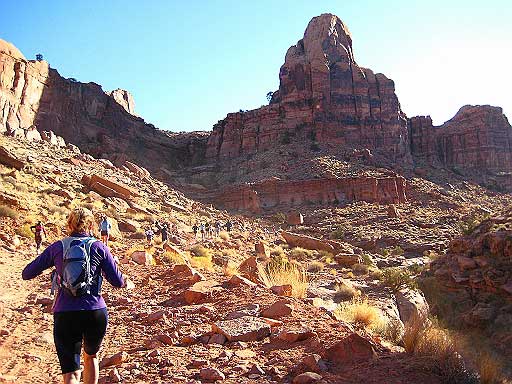
Once the race was underway at 8:34 a.m. (starting line located at N 38.32.114, W 109.35.965), runners were bunched for the first mile or so, and then things spread out until about mile 4.5 when runners came out of Pritchett Canyon. As usually, I spent the first several minutes of the run taking pictures and video, feeling comfortable being near the back of the pack. I twisted my ankle slightly about mile 2.5, think that this could be a quick end to my day. However, I was feeling good, and I struck up a short conversation with a runner named Bruno from Canada who came all the way to Utah for the race (In fact, almost everyone I spoke with during the run was from outside the state----impressive that the race would draw such a crowd).
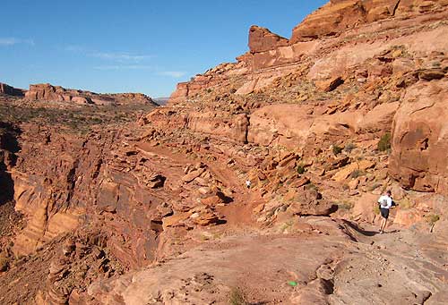
Once out of Pritchert Canyon (N 38.30.717, W 109.32.982), we dropped down a hill and then continued on a relatively flat Jeep trail until the first aid station at mile 5.8 miles. It was well stocked with chips, pretzels, M & Ms, fudge, and oranges. I grabbed a few snacks, added some water to my bottles, and was off. The scenery in this part of the course is just spectacular, and I had to stop a few times to soak up the views and take more pictures. One really impressive part were the views down into Hunter Canyon, which I would be entering shortly for an in-and-out section of the course.
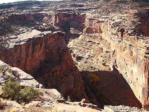
The jeep trail turns into a single-track, semi-technical section, and I was still feeling strong as the course reached the 9 mile mark as it descended along some sandstone cliffs until the bottom where you meet the second aid station at about mile 10 at N 38.30.908, W 109.35.968. Checked my watch: 10:40 a.m. After grabbing a few orange slices and fudge, I was off running down Kane Creek Road for half a mile until I reached the trailhead of Hunter Canyon at N 38.30.602, W 109.35.819. There was a water-only aid station at this point. This section of the race requires you to enter the canyon about 1.7 miles, punch your bib with a punch hanging from a branch (or was it a rock?), indicating that you actually reached the turn-around point, and then come out. The topography and ambience of the whole area were very interesting; the sand was not. I felt like I was running along a beach. It was also fun to see all of the runners ahead of you, for that would be the last time I would see any of them. I was definitely near the back of the pack, but the views---and spending time taking pictures because I might not return---kept me busy.
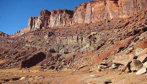
Once out of the canyon, I grabbed some water and took a left along the road until you entered a sandy trail that led you to the massive wall referred to as the Scorched Earth Wall at about N 38.30.161, W 109.36.476. My watch said 11:43 p.m. My original plan was to try to complete the first loop of 20 miles in about 5 hours (around 1:30 p.m.), but my GPS was saying that the course was already longer than posted---about 2 miles longer at this point, bringing me to about 15 miles at this point. The hike up this section for about 1,000 feet was somewhat tedious, and I was glad to reach the top.
After reaching the top of this climb, you can see fantastic views off to the west as you descend on what is referred to as Nellie's Trail for a couple of miles, through, up, and over some very interesting slickrock sections until I reached the 3rd aid station at N 38.30.467, W 109.36.914. My clocked said 12:59 p.m. During this last section, I met a friendly woman from Wyoming, and like so many other runners during the day, she took the time to take a picture for me. Once at the aid station, I let the volunteers know that the runner that I met a couple miles back (the man who had little water) might need assistance and then I had my fill of oranges, pretzels, and other snacks (plus loaded my bottle), and off I went. From here, you soon find yourself on the Cliff Hanger Trail widely used by mountain bikers in the area. You also get some great views of Jackson Hole to your left and the potash factory in the distance.
Following this trail for about 2,5 miles brings you to the 4th and final aid station during the first 23.5 miles at N 38.31.763, W 109.37.914. As always, the aid station was well-stocked with plenty of items and friendly and encouraging volunteers. After a minute or two there, I crested the hill to the right, and I could see the finish line for the 20-mile race in the distance. At this point, I overhead a woman talking about trying to make the cutoff by 3:00 p.m. for those who wanted to continue on for the 50K. For some time, I was going back and forth on whether I had time to try to finish the race, but the woman seemed positive about the prospects of making the cut off, so I felt resolved in mind mind to give it a try. Why not? The final leg of this run for this section descended on the single-track Jackson Trail along the Colorado River . . . again, fantastic views. It was 1:37 when I left the last aid station, and I arrived at the 23.5 mile mark (the finish line for the 20-milers at 2:14 p.m. I was a little surprised how well l felt . . . not breaking any time records, but I knew I just wanted to press on and see how far I could go. After take a couple of minutes to refuel, I headed off for the final 10-mile loop. The first mile of this section was slow going, starting with climbing up a roped section, up and down along sand and slick rock, until reaching the road for a mile run to the start of the Moab Rim trail. My brother met me along the road section to give me some encouragement. By this time, the leaders were finishing this loop, and you could tell from some of their faces there wasn't much pleasure for me up ahead. Upon hitting the road, it was about a 1/2 mile run to the aid station right before the one mile-climb up to the Moab Rim. From this aid station it would be a five-mile loop on top, and you needed to punch your bib to indicate you actually made it to the end of the section. As I made the long climb, I occasionally asked me people if the trail leveled of somewhere above, with responses like, "Sort of," "I wish," and a few "Good luck." All I could manage was a steady walk until the top. More runners passed me going the other way as they completed this section. Again, I asked a couple people how far it was to the punch station and what the trail was like up ahead. I wasn't encouraged by one faint, "You don't want to know." Finally one runner warned me up the sand dune I would have to climb, and sure enough, there was a tough grind up a sand hill just before the punch. On this stretch of the course, I only saw one other runner, but I figured there might be a couple behind me. When I returned back to the top of the initial climb, I started down hill, and my knees reminded me that this would be slow going. About halfway down, my GPS indicated that I had reached the 31-mile mark, so I was happy that even though I might not make it back to the starting line in time, I was still satisfied with going that far. Earlier in the race, several runners wondered how the race officials would handle the fact that the race was longer than advertised. Near the bottom, my legs started to return, and by the time I hit the bottom, I was feeling somewhat recovered. My brother was waiting there, and the people at the aid station said that they might count my finish if I made it to the finish line along the main road (The race officials decided to allow the later runners to complete the race, due to possible darkness, along the road instead of returning the same earlier route--a more difficult indeed.) I took off, with headlamp on, because the sun was setting, and drivers along the road might not see me. These last section was the fastest for me for the entire race. It was somewhat dark when I pulled in, being the last finisher for the race in 9:00:04. Of course, the awards ceremony had been long over, the food gone, and most of the racers recovering at some hotel or restaurant. Still, I finished my first ultrarun, and I was satisfied with how things turned out. No injuries except for a bruised toenail. Here are some things I learned from the race:
|

| Other Sites |